
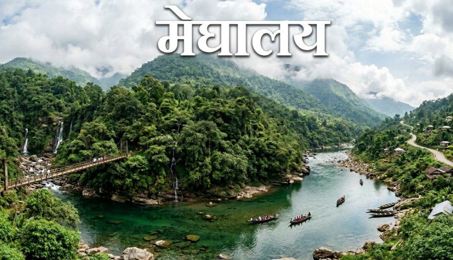
Meghalaya :- The Abode of Clouds, Untamed Nature & Cradle of Living Root Bridges
Detailed History
Tucked away in the mountainous northeastern frontier of India, Meghalaya is universally celebrated as the ‘Scotland of the East‘ due to its undulating green highlands and misty weather. The word ‘Meghalaya’ is derived from classical Sanskrit, literally translating to ‘The Abode of Clouds’. This nomenclature perfectly defines the state’s geographic reality, as it houses the absolute wettest places on the entire planet. According to indigenous mythological narratives, these pristine sub-alpine hills were once the playground of celestial beings, and the deep caves served as sanctuaries for ancient sages performing intense spiritual penance.
Historically, the structural narrative of Meghalaya revolves around three prominent, fiercely independent indigenous tribes—the Khasis, the Jaintias, and the Garos. Prior to British colonial contact, these clans operated under highly organized, democratic traditional governance systems led by chieftains (known as ‘Syiems’ in the Khasi hills). In 1824, following the First Anglo-Burmese War, British forces entered the valley. This sparked a historic armed resistance led by the legendary Khasi patriot U Tirot Sing, who waged an unyielding guerrilla war against British annexation. During the British Raj, the territory was annexed into greater Assam, and due to its cool, therapeutic climate, Shillong was designated as the administrative summer capital of the province. Post-independence, the hill peoples launched a remarkably peaceful socio-political movement demanding a separate identity. This resulted in the creation of an autonomous sub-state in 1970, culminating in the declaration of Meghalaya as a full-fledged sovereign state of the Indian Union on January 21, 1972.
Detailed Architecture :-
The architecture of Meghalaya stands as an extraordinary global testament to bio-engineering, where human utility seamlessly merges with living ecosystems. The state exhibits a fascinating mix of ancient tribal structural forms and British colonial layouts.
Exterior Architecture :–
- The Living Root Bridges :– This is the most stunning example of sustainable bio-architecture on Earth. Hundreds of years ago, the Khasi and Jaintia tribal elders devised a brilliant technique to cross torrential monsoon rivers. They trained the powerful aerial roots of the Ficus elastica (rubber tree) through hollowed-out betel nut trunks placed across river chasms. Over decades, these roots anchored into the opposite riverbanks, weaving into an indomitable, living footbridge. Unlike concrete, these bridges grow stronger with time as the root systems mature, easily supporting the weight of over 50 people simultaneously. The iconic Double-Decker Living Root Bridge in Nongriat stands as the pinnacle of this exterior design.
- Traditional Garo Residential Architecture (Nokmong) :– The classic residential units of the Garo tribe, known as ‘Nokmong’, are constructed entirely using matured bamboo, hardwood posts, and thick thatch insulation. The exterior layout features an elongated, deeply sloped roofline erected on sturdy stilts to clear heavy mountain rainwater runoffs and safeguard the family from wild forest animals.
- Colonial Architecture :– The capital city of Shillong is heavily dotted with heritage British-era brick-and-timber bungalows and high-steepled churches. Their exterior structures combine regional anti-seismic Assam-type wooden frames with classic European Gothic lancet windows and gables.
Interior Architecture :–
- The interior layout of a traditional tribal home features a large communal living room centered around a heavy, stone-and-mud open fireplace (Heartha). This hearth serves as the social anchor of the family, utilized for slow cooking while radiating vital warmth through the uninsulated wooden structure during freezing winters. High bamboo lofts are integrated into the inner roof trusses to dry and store agricultural tools and firewood.
Travel Guide & Routes
Permits and Entry Regulations :–
- Domestic Indian travelers do not require an Inner Line Permit (ILP) to cross into the territory of Meghalaya. However, individual community-managed ecological and heritage reserves levy localized maintenance entry passes.
- Standard entry fees for high-profile natural reserves (Nohkalikai Falls, Elephant Falls, and Mawlynnong village) range from ₹10 to ₹50 per visitor.
- Exploring subterranean limestone mazes like Mawsmai Cave or Arwah Cave requires an entry ticket of ₹20 to ₹40, with separate commercial camera passes costing between ₹50 and ₹100.
Timings (Visiting, Opening & Closing Times) :–
- Best Time to Visit :– The premium window from October to April is highly recommended for standard sightseeing, trekking, and clear panoramic photography. However, if your primary goal is to witness the waterfalls cascading at their most thunderous, majestic capacity, the early monsoon window (June to September) is spectacular.
- Sightseeing Windows :– Major caves, root bridges, and reserves are accessible to tourists from 09:00 AM to 05:00 PM daily. Due to the high altitude, nightfall occurs exceptionally early, and mountain travel post-sunset is strongly discouraged due to heavy fog.
How to Reach (Routes) :–
- By Air :– The domestic Shillong Airport at Umroi offers limited regional air connectivity to Kolkata and Guwahati. The dominant, highly efficient aviation gateway for international and domestic travelers is the Lokpriya Gopinath Bordoloi International Airport (GAU) in Guwahati (Assam), situated roughly 125 km away, offering direct flights to all primary Indian metros.
- By Train :– Meghalaya does not have active high-speed broad-gauge rail connectivity within its mountain limits. The nearest major national railhead is Guwahati Railway Station. From the station gates, dedicated shared tourist cabs and state-run luxury buses operate continuous routes to Shillong.
- By Road :– The overland journey from Guwahati to Shillong via National Highway 6 (NH-6) is an exceptionally scenic, smooth four-lane highway corridor. The route wraps around the vast blue expanses of Umiam Lake and takes roughly 3 to 4 hours of driving time via car.
Photography Spots, Local Cuisine, and Famous Markets
Photography Spots :–
- Nongriat Double-Decker Root Bridge :– Ideal for capturing otherworldly frames of the two-tiered living root structure framed against dense tropical ferns and a clear turquoise jungle pool.
- Umiam Lake Viewpoint :– Captures grand, tranquil waterscapes showcasing solitary pine-fringed islands reflecting beautifully against the water during sunrise.
- Umngot River (Dawki) :– Renowned globally for producing viral photographs where the water is so impeccably translucent that boats appear to be floating mid-air over a dry riverbed.
- Laitlum Canyons :– Offers magnificent, moody wide-angle frames of massive, deep vertical gorges shrouded in shifting curtains of mountain mist.
Local Cuisine :–
- Jadoh & Dohkhlieh :– The authentic culinary heritage of the Khasi hills is deeply unique. The undisputed staple is ‘Jadoh’—a rich, flavorful dish of indigenous short-grain red rice cooked with specific aromatic spices. This is frequently paired with ‘Dohkhlieh’ (a clean, rustic salad made of boiled minced meat, pungent local ginger, and green chillies) and ‘Pukhlein’ (a crispy, comforting sweet bread made of fried rice flour and liquid jaggery). Offering ‘Kwai’ (a traditional combination of raw betel nut, pan leaf, and lime) is the ultimate gesture of social welcome.
Famous Markets :–
- Lewduh Market (Bara Bazar – Shillong) :– One of the oldest, largest traditional open-air bazaars in Northeast India, managed almost entirely by Khasi women. It is an exceptional spot for documenting indigenous trade and purchasing wild forest honey, local wild mushrooms, and bamboo wickerwork.
- Police Bazar :– The bustling, modern commercial heart of Shillong, packed with contemporary cafes, winter garments boutiques, and highly rated street-food stalls serving steaming momos.
Nearby Attractions
- Cherrapunji (Sohra) & Mawsynram :– These legendary high plateaus hold the undisputed title of being the wettest zones on Earth. They house the iconic Nohkalikai drop-waterfall, the structural eco-parks, and deep limestone cave networks.
- Mawlynnong :– Universally celebrated as ‘Asia’s Cleanest Village’. It features immaculate flower-lined stone pathways, eco-friendly bamboo waste bins, and an exemplary community-led garbage recycling system.
- Dawki :– A vibrant border settlement on the edge of the international Indo-Bangladesh frontier, highly sought-after for boating and camping along the crystal-clear currents of the Umngot River.
- Shillong Peak :– The highest geographic elevation point in the district, granting tourists an uninterrupted, breathtaking 360-degree panoramic view of the entire capital city sprawl and distant Himalayan foothills.
- Jaintia Hills & Nartiang Monoliths :– A deeply historic area housing the largest collection of ancient stone monoliths in the state, erected centuries ago to mark the glorious victories of the ancient Jaintia kings.
Important Questions and Answer :-
Question 1:- What is the unique engineering process behind the creation of Meghalaya’s Living Root Bridges?
Answer:– The living root bridges are not built; they are grown over generations. Khasi and Jaintia tribal architects guide the flexible aerial roots of living Ficus elastica trees across raging rivers using hollowed-out betel nut tree trunks as directional pathways. Once the roots cross the chasm and plant themselves firmly into the opposite bank’s soil, they grow thick and woody. Over decades, they entwine to form an unbreakable, self-healing biological bridge that thrives in high-moisture conditions.
Question 2:- What causes the absolute clarity of the Umngot River in Dawki?
Answer:– The transparent nature of the Umngot River is a combination of strict community environmental protection and geographic luck. The river flows over a clean, solid rocky bed preventing mud suspension, and the upstream tribal villages strictly enforce absolute prohibitions against dumping any synthetic waste or washing commercial vehicles in the water, preserving its glass-like optical purity.
Question 3:- How does the family lineage system operate under Meghalaya’s Matrilineal Society?
Answer:– Unlike typical patriarchal structures, the primary tribes of Meghalaya follow a strict ‘matrilineal’ system. Ancestral surnames and clan lineages are passed down directly from the mother to her children. Furthermore, the ancestral family wealth and property are legally inherited by the ‘Khadduh’—the youngest daughter of the household, who also assumes the role of taking care of the aging parents.
Question 4:- How did Mawlynnong achieve its global reputation as Asia’s Cleanest Village?
Answer:– Cleanliness in Mawlynnong is not an administrative rule; it is an organic cultural values asset. Every single villager participates in daily sanitation. Children sweep the lanes cleanly every morning, all organic refuse is strictly collected in hand-woven bamboo baskets and converted into agricultural compost, and plastic utilization is highly restricted throughout the settlement limits.
Question 5:- What unique geographic status does the Nohkalikai Waterfall hold in India?
Answer:– Dropping from an altitude of approximately 1,115 feet, Nohkalikai Falls is celebrated as the highest plunge-type waterfall in India. Instead of cascading down stepped rocks, the water leaps cleanly off a sheer forested cliff edge, free-falling straight down into a dramatic, deep green plunge pool carved out of the valley floor.
Author’s Thoughts :-
To travel through Meghalaya is to step completely out of the ordinary world and enter a mystical realm where nature and human spirit exist in an eternal embrace. Standing on the edge of the Laitlum Canyons, watching massive waterfalls trace silver lines down vertical green cliffs while sheets of white cloud drift past your face, is a deeply humbling experience. The true genius of Meghalaya lies not just in its dramatic landscapes, but in the profound wisdom of its people. In an era dominated by synthetic concrete, their living root bridges and crystal-clear rivers stand as a glowing global lesson in ecological respect and sustainable living. Whether you are walking through the immaculate, quiet lanes of Mawlynnong or listening to the deep roar of the monsoons in Sohra, this land infuses you with a rare, quiet peace. Meghalaya remains an essential pilgrimage for the soul—a place that permanently expands your reverence for the natural world.
Si“Where human hands grow living bridges out of ancient roots, and the rivers flow like clear glass, Meghalaya stands as nature’s ultimate masterclass.”